
WALLED CITY OF CHARLES TOWN
The question of who owned the huge swath of land south of Virginia, north of St. Augustine, and west to the Pacific Ocean was hotly debated when the first permanent English settlers arrived aboard the Carolina in 1670. Settlers had to be wary of many enemies, both on land and at sea. The Spanish in St. Augustine perennially raided the area, making life difficult for local Native Americans. Because of that some local tribes, though not all, welcomed the English and their advanced weaponry. Meanwhile the French continued looking for their chance to claim land along America’s eastern seaboard, and pirates established havens all along Charles Town’s coast.
Though they first settled about 10 miles up the Ashley River, early colonists, by 1680, had begun to relocate the colony to the peninsula we know as Charleston today, feeling it was a more defendable position. That the sea breeze helped mitigate the hordes of biting mosquitos may also have been a factor in that decision.
Charles Town was carefully planned. Known as the “Grande Modell,” that plan designated civic spaces and residential lots, all protected by a wall that included defensive fortifications made of wood, earth, brick and stone. With its forts, curtain walls, moats and drawbridges, Charles Town became the only English walled city in America. (The Spanish similarly protected St. Augustine, as did the French Quebec, and the Dutch New Amsterdam, later renamed New York.)
Unfortunately the colony began outgrowing its footprint before the wall was even completed. The north, west and south walls, made mostly of earthworks with a moat, had been basically dismantled by 1730. The eastern coastal wall, however, was constructed of brick in a sturdy English bond pattern. Fifteen feet above the low water mark and five feet above street level, the wall continued to defend the city through the American Revolution. Over time however, even that wall was damaged, built over, or absorbed into other structures.
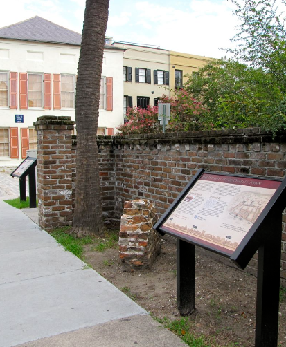
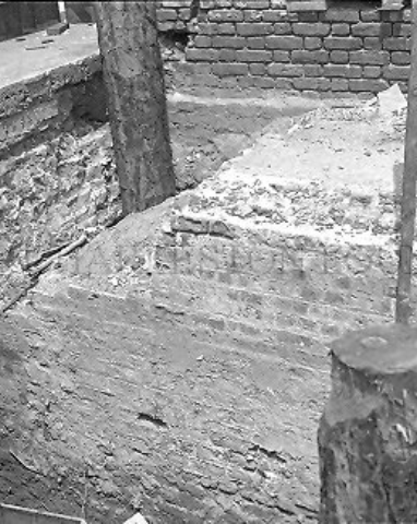
Many are unaware the wall still lies beneath the city. A portion of the southeast fort, Granville Bastion, was uncovered in 1925 below the Capt. James Missroon House, c. 1808. Excavations of the Old Exchange Building, c. 1767, in 1965 exposed remains of Half Moon Battery just below street level. During restoration of the Charleston County Courthouse (originally the S.C. State House), c. 1790, which was heavily damaged in Hurricane Hugo (1989), four cedar posts were uncovered that archaeologists believe to have been part of a drawbridge.
More of the wall was found in 2008-2009 during underground utility repairs at South Adger’s Wharf and East Bay Street. Excavated under the aegis of the Mayor’s Walled City Task Force, the dig yielded remnants of a triangular fortification known as a redan. Task force members recovered a number of artifacts, mostly colonial shoe soles, pipe stems and sections of the wall before the street was recobbled. One section is on display at The Charleston Museum and another displayed near its original location.
Sources & More Information
Redisicovering Charleston's Colonial Fortifications, a blog by Dr. Nicholas Butler, co-chair of the Mayor's Walled City Task Force.
Charleston's Walled City Task Force Facebook Page.
Charleston's Defensive Strategy of 1703. Podcast by Dr. Nicholas Butler, Charleston County Public Library, Dec. 3, 2021.
Creating a Walled City: The Charleston Enceinte of 1704. Podcast by Dr. Nicholas Butler, Charleston County Public Library, Friday, April 22, 2022.
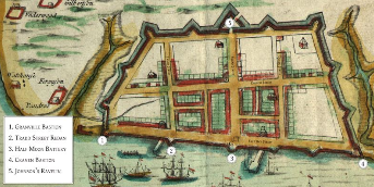

Detail of a view of Charles Town, c. 1690
